
AI for Government
Ocean Data and Government AI: How IoT Sensors and AI Transform Marine Monitoring
Governments invest billions in ocean IoT sensors and AI analytics to meet BBNJ treaty obligations, protect marine biodiversity, and unlock the $3 trillion blue economy.
Sofia Fominova
Apr 13, 2026

Ocean data is the foundation of government climate policy, maritime security, and blue economy strategy. With the marine IoT market reaching $7.79 billion in 2025 and AI-powered ocean monitoring growing at 18.2% annually, governments that invest in ocean data infrastructure gain a decisive advantage in environmental compliance, disaster preparedness, and economic planning.
Key Takeaways
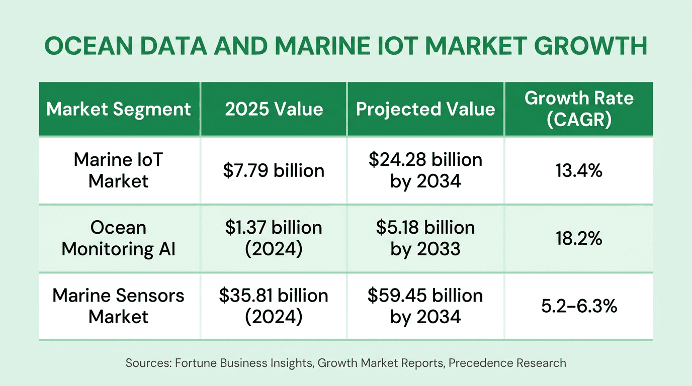
The global marine IoT market reached $7.79 billion in 2025, with projections to exceed $24 billion by 2034, according to Fortune Business Insights.
The BBNJ High Seas Treaty entered into force on 16 January 2026, creating new data requirements for marine protected areas in international waters.
Only 3.2% of the global ocean is currently fully or highly protected, against the 30x30 target of 30% by 2030, according to the Marine Conservation Institute.
The ocean monitoring AI market is valued at $1.37 billion (2024) and growing at 18.2% CAGR, per Growth Market Reports.
The Global Ocean Observing System (GOOS) now operates 9,389 platforms across 64 member states, generating over 120,000 observations per day.
Net0, an AI infrastructure company that builds AI solutions for governments and global enterprises, provides the kind of government AI platforms that enable nations to collect, process, and act on ocean data at scale. As international treaties mandate new levels of marine environmental monitoring, AI-driven ocean data intelligence is becoming a strategic imperative for governments worldwide.
Ocean data encompasses the continuous measurement of marine parameters -- temperature, salinity, pH, dissolved oxygen, carbon dioxide concentrations, current patterns, and biological indicators -- collected through networks of IoT sensors, autonomous vehicles, and satellite systems. For governments, this data informs policy on climate mitigation, biodiversity protection, fisheries management, disaster preparedness, and economic development across the blue economy.
The Scale of Government Ocean Data Collection in 2026
Government investment in ocean data collection has accelerated dramatically in the past decade. The infrastructure underpinning marine monitoring now represents a multi-billion-dollar global commitment, driven by climate obligations, biodiversity treaties, and the economic potential of the blue economy.
According to Fortune Business Insights' 2025 analysis, the underwater and marine IoT market reached $7.79 billion in 2025 and is projected to grow to $24.28 billion by 2034 at a 13.4% CAGR. The broader marine sensors market, valued at $35.81 billion in 2024 by Precedence Research, is expected to reach $59.45 billion by 2034.
The GOOS Status Report 2025 documents the scale of this infrastructure: 9,389 operational ocean observing platforms across 17 networks and 64 member states, producing more than 120,000 observations per day. These networks include Argo profiling floats, data buoys, ship-based observation teams, and emerging systems such as SMART subsea cables and uncrewed surface vehicles.
This data volume has practical implications for government operations. IoT sensors now enable the collection of as much ocean data in a single year as was gathered in the entire previous century using traditional methods, according to the World Economic Forum.
How IoT Sensors Enable Continuous Marine Monitoring
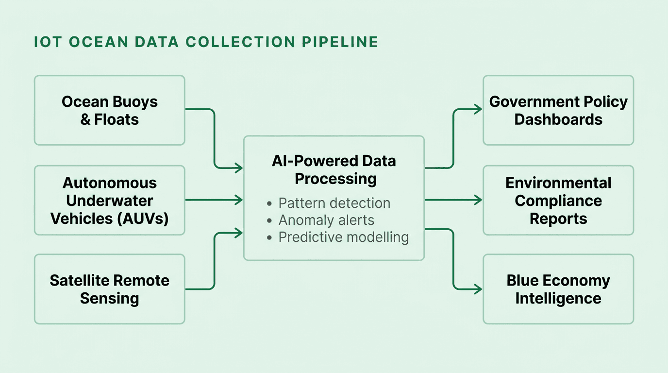
IoT sensors have replaced the limitations of manned oceanographic expeditions -- constrained by cost, accessibility, and safety -- with scalable, continuous, and autonomous monitoring networks. Four technological developments drive this transformation.
AI-Embedded Sensing. Modern marine sensors integrate AI and machine learning directly into hardware. Edge AI chips process data on-site, reducing latency and bandwidth requirements for remote deployments, according to Growth Market Reports' 2024 ocean monitoring analysis. These devices measure temperature, salinity, pH, dissolved oxygen, and carbon dioxide concentrations with high precision, transmitting processed insights rather than raw data.
Global Connectivity. Integration with satellite and cellular networks enables real-time data transmission from the most inaccessible ocean regions. AI-enabled hybrid acoustic-optical mesh networks, as documented by Mordor Intelligence, overcome traditional bandwidth limitations in deep-sea environments, ensuring continuous data streams to centralised government databases.
Miniaturisation and Durability. Compact, energy-efficient sensors now operate in extreme conditions -- from shallow coastal zones to deep-sea trenches -- for extended periods without maintenance. This durability enables widespread deployment across diverse marine environments, generating the sustained data streams essential for long-term trend analysis.
Interdisciplinary Applications. The same sensor platforms serve environmental monitoring, maritime security, climate research, fisheries management, and disaster response. Autonomous underwater vehicles (AUVs) equipped with LiDAR conduct infrastructure inspections on offshore wind turbines and coral reefs simultaneously. This versatility consolidates government investment across multiple operational mandates.
Government Applications of Ocean Data
Ocean data serves five distinct government functions, each with direct policy and operational implications. Effective data collection requires AI-powered platforms capable of integrating diverse sensor feeds into actionable intelligence -- the kind of government AI infrastructure that processes environmental data at national scale.
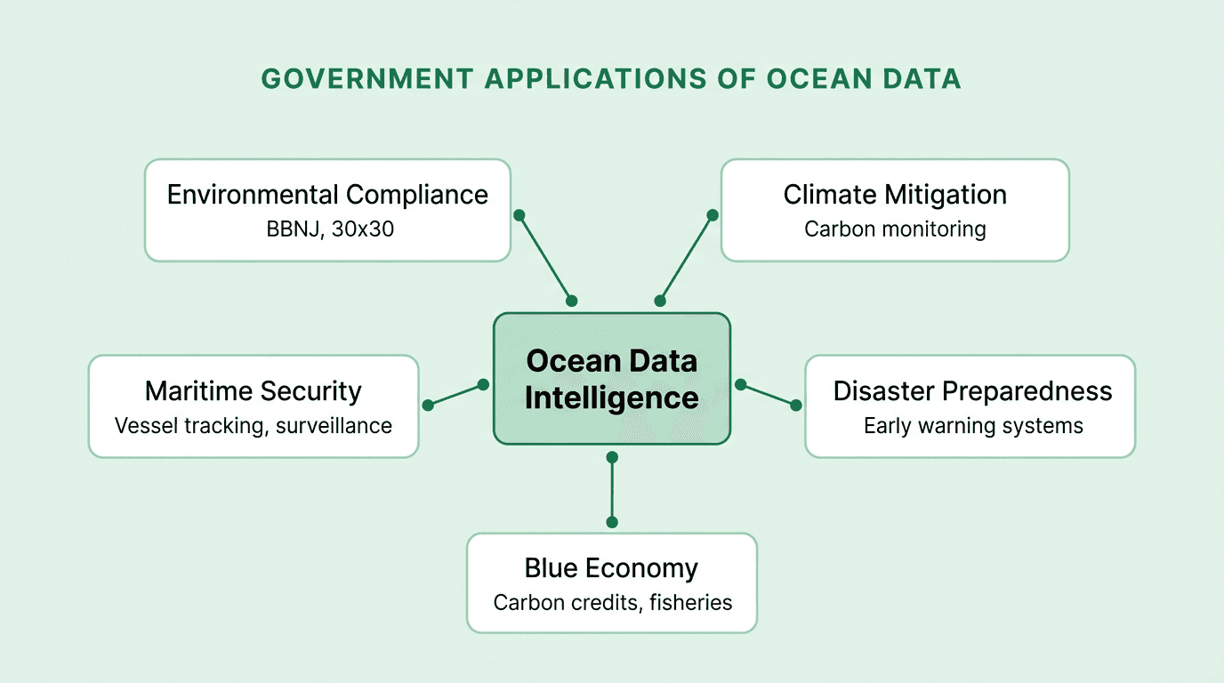
Environmental Compliance
The BBNJ Agreement (the High Seas Treaty), which entered into force on 16 January 2026 with 82 ratifications, establishes a legal framework for marine protected areas in international waters and mandates environmental impact assessments. Compliance requires continuous monitoring data -- carbon dioxide levels, biodiversity indicators, and ecosystem health metrics -- that only networked IoT sensors can provide at the necessary scale. In the Arabian Gulf, sensor networks measure salinity, temperature, and CO2 levels, providing evidence for regional marine conservation discussions and international climate agreement compliance.
The Kunming-Montreal Global Biodiversity Framework's 30x30 target -- protecting 30% of marine areas by 2030 -- faces a substantial gap. According to the Marine Conservation Institute's 2025 assessment, only 3.2% of the global ocean is currently fully or highly protected. Closing this gap requires extensive monitoring infrastructure to designate, manage, and verify marine protected areas.
Climate Mitigation
Oceans absorb approximately 30% of anthropogenic carbon dioxide and 93% of excess heat generated by greenhouse gas emissions. Long-term monitoring of these processes is essential for climate policy. In the UAE, government-deployed IoT sensors monitor marine ecosystem health and inform carbon reduction initiatives. Off the coast of California, decades of sensor data on ice melt and ocean temperatures have justified the expansion of marine protected areas that function as carbon sinks.
This data supports decarbonisation strategies at the national level by quantifying the ocean's role in the carbon cycle and identifying where intervention is most effective. AI-powered analytics transform raw sensor readings into the emissions reporting frameworks that governments require for international climate commitments.
Pollution Control
In the shipping lanes of the Arabian Sea, IoT sensors track waste disposal practices, detecting illegal dumping in near-real-time. Satellite imagery enhanced by AI analysis has increased vessel detection coverage by 30%, according to Global Fishing Watch's 2024 research, including identification of smaller vessels under 10 metres that previously evaded radar detection. Governments in Oman have used this sensor data to implement stricter enforcement against illegal dumping, measurably reducing pollution levels.
Disaster Preparedness
Coastal communities face increasing threats from hurricanes, tsunamis, and storm surges. IoT sensors detect the subtle oceanic changes -- pressure shifts, temperature anomalies, wave pattern alterations -- that precede extreme weather events. Early warning systems built on continuous sensor data enable timely evacuations, saving lives and reducing economic damage. These systems are especially critical in regions like Florida, the Gulf states, and Southeast Asia, where ocean-driven natural disasters pose recurring threats.
Sustainable Fisheries Management
IoT sensors monitor fish populations, providing real-time data on species health, migration patterns, and population counts. According to NOAA Fisheries, advanced technologies including uncrewed systems, passive and active acoustics, and remote sensing are transforming fisheries data collection. Governments use this data to set and enforce fishing quotas, ensuring that marine resources remain viable for future generations. Along the coast of Maine, sensor-informed quota management has helped maintain the balance of marine ecosystems on which thousands of livelihoods depend.
Economic Value of Ocean Data for Governments
The global ocean economy contributes over $3 trillion to global GDP and employs more than 100 million people worldwide, according to the OECD's 2025 analysis. The OECD documents that the ocean economy doubled in real terms from $1.3 trillion in 1995 to $2.6 trillion in 2020, and would rank as the world's fifth-largest economy if measured as a nation. Data-driven governance of this economy requires the kind of AI infrastructure that integrates environmental, economic, and compliance data streams.
Blue Carbon Credits. Coastal blue carbon ecosystems -- mangroves, salt marshes, and seagrass meadows -- represent a sequestration potential valued at up to $190 billion per year, according to the World Bank's 2023 assessment. The United States became the first nation to include blue carbon in its national greenhouse gas reporting inventory, supported by NOAA's coastal land cover programme. Quantifying and trading these credits requires continuous monitoring of ecosystem health -- precisely the data IoT sensors provide.
Offshore Energy. Ocean data informs the siting, construction, and operation of offshore wind farms and wave energy installations. In the Middle East, countries like the UAE are leveraging marine data to develop renewable energy sources, creating jobs and diversifying economies away from fossil fuel dependence.
Long-Term Economic Planning. In the UK, government agencies use long-term data on sea levels, temperature changes, and marine biodiversity to plan coastal defence systems, designate marine protected areas, and develop strategies that balance economic development with environmental sustainability. This data-driven planning connects directly to the profitable decarbonisation strategies that align economic growth with climate commitments.
Job Creation. The WEF's Ocean Economy Imperative report (2026) identifies ocean-related startups valued at $120 billion collectively, with potential to grow to $1.3 trillion. The deployment and analysis of ocean data creates employment across research, technology, marine engineering, and data science.
International Ocean Governance and Data Requirements
Three international frameworks are shaping government demand for ocean data infrastructure in 2026.
The BBNJ High Seas Treaty. Entering force on 16 January 2026 with 82 ratifications, this treaty provides the first legal mechanism for establishing marine protected areas beyond national jurisdiction. It mandates environmental impact assessments and equitable benefit-sharing of marine genetic resources. Implementation requires continuous data on biodiversity, ecosystem health, and human activity in international waters -- data that autonomous sensor networks are uniquely positioned to deliver.
The 30x30 Target. Established under the Kunming-Montreal Global Biodiversity Framework at COP15 in 2022, this target requires 30% of marine and coastal areas to be effectively protected by 2030. With only 3.2% currently protected to a high standard, achieving this goal will require unprecedented expansion of monitoring infrastructure to identify, designate, and verify marine protected areas.
The UN Decade of Ocean Science for Sustainable Development (2021--2030). At its halfway point, the Ocean Decade has catalysed global investment in ocean observation. The 2024 Barcelona Statement set priorities for the Decade's second half, emphasising ocean knowledge generation and pollution monitoring. The next major milestone is the 2027 Ocean Decade Conference in Rio de Janeiro. The Global Ocean Observing System (GOOS), coordinated by UNESCO's Intergovernmental Oceanographic Commission, provides the backbone infrastructure with 9,389 platforms across 64 member states generating over 120,000 observations daily.
These frameworks create compliance obligations that require governments to invest in continuous, AI-powered monitoring systems. Nations that build this infrastructure early gain both regulatory compliance and strategic advantage in ocean governance discussions.
AI-Powered Analysis of Ocean Data
The ocean monitoring AI market reached $1.37 billion in 2024 and is growing at 18.2% CAGR, projected to reach $5.18 billion by 2033, according to Growth Market Reports. This growth reflects a fundamental shift: the volume and complexity of ocean data have outpaced human analytical capacity. AI is no longer optional for marine monitoring -- it is the only viable approach at scale.
Pattern Detection and Anomaly Identification. AI systems continuously analyse data on ocean temperature, salinity, and pH levels to detect early signs of ecological changes. Harmful algal blooms, shifts in marine biodiversity, and emerging pollution events that would be undetectable through manual analysis are identified in near-real-time. According to MarketsandMarkets' analysis, AI is shifting marine sensing from passive data collection to active, intelligent systems capable of acoustic signature classification and autonomous decision-making.
Neural Network Enhancements. NOAA upgraded its Extended Reconstructed Sea Surface Temperature (ERSSTv6) dataset using an artificial neural network, improving spatial correlation coefficients by 5% and reducing root-mean-square-difference errors compared to the previous version. This kind of AI-driven data quality improvement has direct implications for the accuracy of climate models and policy decisions.
Satellite and Optical Integration. AI-driven analysis of optical satellite imagery from sources like Sentinel-2 has expanded vessel detection coverage by 30%, according to Global Fishing Watch. This technology enables governments to monitor illegal fishing, shipping lane violations, and unregistered vessel activity with unprecedented granularity.
Edge AI and Autonomous Systems. Integration of AI chips directly into sensor hardware and autonomous underwater vehicles enables on-site data processing, reducing latency and bandwidth requirements for remote ocean monitoring. This is particularly critical for deep-sea and Arctic monitoring stations where connectivity is intermittent.
How Net0 Supports Government Ocean Data Intelligence
Net0, an AI infrastructure company founded in 2021 in Dubai, builds AI solutions that enable governments to process and act on large-scale environmental data. The platform's architecture -- encompassing sovereign AI infrastructure, custom AI models, and cross-agency data integration -- addresses the core challenges of government ocean data programmes.
Net0's sustainability platform provides automated data collection from over 10,000 systems, real-time environmental dashboards, and multi-framework reporting across 30+ standards including those relevant to marine environmental compliance. For governments managing ocean data alongside broader emissions tracking across Scope 1, 2, and 3, Net0 consolidates diverse data streams into unified intelligence.
The platform's sovereign and hybrid deployment options ensure that sensitive government ocean data remains under national control -- a requirement that is becoming non-negotiable as countries implement the BBNJ treaty and expand their marine monitoring capabilities. With 60+ modular AI applications, Net0 provides the analytical infrastructure that transforms raw ocean sensor data into the policy-grade intelligence governments need.
Book a demo to learn how Net0's AI infrastructure supports government environmental monitoring programmes.
What is ocean data and why does it matter to governments?
Ocean data refers to the continuous measurement of marine parameters -- temperature, salinity, pH, dissolved oxygen, carbon dioxide, current patterns, and biological indicators -- collected through IoT sensors, autonomous vehicles, and satellites. Governments require this data for climate policy compliance, biodiversity protection, fisheries management, disaster preparedness, and economic planning across the blue economy, which contributes over $3 trillion to global GDP according to the OECD.
How has the BBNJ High Seas Treaty changed ocean data requirements?
The BBNJ Agreement entered into force on 16 January 2026 with 82 ratifications, establishing the first legal framework for marine protected areas in international waters. It mandates environmental impact assessments and continuous monitoring, requiring governments to invest in networked IoT sensor infrastructure and AI-powered analytics to meet compliance obligations.
What role does AI play in ocean data analysis?
AI transforms raw ocean sensor data into actionable intelligence at a scale impossible through manual analysis. Applications include real-time anomaly detection for harmful algal blooms, neural network-enhanced climate datasets (such as NOAA's ERSSTv6), satellite-based vessel tracking with 30% greater coverage, and autonomous underwater vehicle operations. The ocean monitoring AI market is valued at $1.37 billion and growing at 18.2% CAGR.
How large is the marine IoT sensor market?
The marine IoT market reached $7.79 billion in 2025 and is projected to grow to $24.28 billion by 2034, according to Fortune Business Insights. The broader marine sensors market was valued at $35.81 billion in 2024 by Precedence Research. The Global Ocean Observing System operates 9,389 platforms across 64 member states, generating over 120,000 observations per day.
What is the 30x30 ocean protection target?
The 30x30 target, established under the Kunming-Montreal Global Biodiversity Framework at COP15 in 2022, aims to protect 30% of global marine and coastal areas by 2030. As of early 2026, the Marine Conservation Institute reports that only 3.2% of the ocean is fully or highly protected. Achieving this target requires significant expansion of ocean monitoring infrastructure.
How does ocean data support the blue economy?
Ocean data underpins blue economy sectors worth over $3 trillion globally. Specific applications include blue carbon credit quantification (coastal ecosystems valued at up to $190 billion per year in sequestration potential), offshore energy siting, sustainable fisheries management, and coastal defence planning. The World Economic Forum's 2026 Ocean Economy Imperative report identifies ocean-related startups valued at $120 billion with potential to reach $1.3 trillion.
How does Net0 support government ocean data programmes?
Net0 provides AI infrastructure for governments that includes sovereign deployment options, automated data collection from 10,000+ systems, real-time environmental dashboards, and multi-framework reporting across 30+ standards. The platform enables governments to consolidate ocean sensor data alongside broader emissions tracking into unified policy intelligence, with sovereign and hybrid cloud options that maintain data under national control.
